


|
||
|
|
|
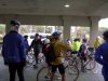
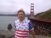
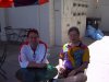
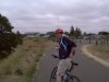
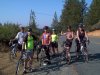
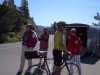
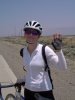
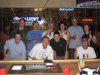
Day 1 - June 8 - San Francisco, CA to Fairfield, CA - 81 milesActually, the trip starts from Millbrae, next to the San Francisco airport. We bike up into San Francisco to dip our wheels in the Pacific at Golden Gate State Beach. Then across the Golden Gate Bridge, and around the bay to the north. "WRS" is the corporate headquarters of my employer, Wind River Systems, in Alameda. If you skip ahead to day 51 or day 52, you'll see the Nashua NH office where I actually work, marked as "WORK". I flew out on Wednesday to visit friends and family. Unfortunately, I didn't have excess vacation time. Actually, I'm going to be borrowing vacation time, and the last week or so is going to be unpaid leave. So I worked out of the Alameda office on Thursday and Friday. Met the group today. 25 riders are going all the way through. 9 more riders are starting with us, but dropping off at various points, and we pick up other riders along the way. We have three Dutchmen: Fred from Rotterdam, John from Groningen, and Daco from Amsterdam. Plus one Brit: Andy from Derby (pronounced "Darby") in the Midlands. Dan from North Carolina has a prosthetic leg. The rest of us are not as outwardly noteworthy, but I'm sure we'll soon display our uniqueness. My roommates are Andy, the aforementioned Brit, and John, from Folsom CA. Andy's been out of work since December, and came here from an extended trip to Australia and New Zealand. He's never been to the States before, but what better way to really experience it?
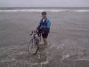
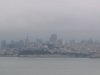
There was a solid mile of climbing right at the start, up to Skyline Blvd. In all, we did 3300 ft of climbing today, mostly at the beginning. The ceremonial wheel dip was at the Golden Gate State Beach. I wasn't planning to immerse my drive-train, but oh well. The real problem was that I overloaded the rack trunk, and I couldn't easily carry the bike over the sand, so I rolled the wet wheels through the sand, and spent the next 20 minutes cleaning sand out of my brakes. Cleaned the rest of the bike back at the hotel. We ran into the AIDS Ride or something going south on Rt 35 while we were going north - hundreds of bike, numerous bikers in costume. I knew the fog was bad when I couldn't see the other side of Rt 35. In Daly City, we biked right past the stable where my coworker Lisa and I rented horses to go riding on the beach last year. There was also a triathlon from Golden Gate Beach to the bridge. The police re-routed us around part of the race, but we ended up joining it on the climb to the bridge. Suddenly people were cheering us, saying things like "you're almost there!" But we're on our way to New Hampshire. First sag stop was at the far end of the Golden Gate Bridge. I was with Julie, Kathy, and Cindy, and we were the last group out of the beach stop, so I was mighty surprised to find that we were one of the first groups into the sag. I think a lot of people got lost. ("SAG" stands for "Support and Gear." Or "Stuff and Go," because some people just grab a few granola bars, and get back on the road.) Julie was our leader today, through various permutations of "us". She's one of the stronger riders, she doesn't let anything stop her, and, most importantly, she has a handlebar holder for the cue sheets. Today's cue sheet was 3 pages of text, plus 7 maps. Sausolito looks pretty, but we didn't stop. Likewise San Rafael (pronounced "San Rafel"). Biked right past the gates of San Quentin Prison. Lunch at Jack in the Box in Ignacio, because it was the last food before Vallejo (about 20 miles on). San Rafael would have been much better. Spent a while on Rt 37, which is both narrow and busy. Got on west-bound, when we meant to get on east-bound. After a lot of deliberation, we ended up running across the highway, and jumping the guardrail on the median. In Vallejo, we passed a bunch of signs that just said "America", with arrows. It turns out that America is a subdivision. Insert punchline here. Or maybe that is the punchline.
There was a cameraman from ESPN-2 filming us today, for a piece on Dan. He's going to be joining us again on Thursday, and then I guess they're filing the story. 5 riders rode in about 7:30. They didn't get too far lost, but Jason had two flats, and Carol had one, in the first 10 miles. They hadn't even gotten to the beach by the time everyone else left. And so it went for them - more flats, more troubles. They got to the first sag stop at the bridge, while we were at the second sag in San Rafael. |


|
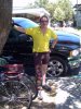
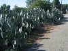
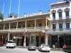
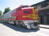
Day 2 - June 9 - Fairfield, CA to Sacramento, CA - 57 milesNice, flat, short ride. Rode mostly with Andy and Dan. I ended up leading, because Andy lost his cyclometer yesterday on Route 37. While passing a parked car in the breakdown lane, he had to go over the rumble strip, and the cyclometer bounced off into traffic. Suzanne took a bad spill, and hurt her wrist. Dan (who used to be an Army medic) taped it up with what was available - duct tape. Saw a road-killed bobcat today. Also great groves of cactus. Lunch in Davis, just outside the University campus. The directions into town were a mite confusing, so we ended up wandering around. Wandered right into a bike store, where Andy got a new cyclometer, and Dan got a new rack. They have wonderful bike trails out here. Wandered down to Sacramento Old Town, which is sort of faux/restored Old West. Bought a couple postcards, then went into the real downtown area to find the post office. At said post office, I had to go through an airport-sytle security screening, just to buy some stamps. They didn't even have a self-service stamp machine outside the security area. Then tried to find an internet cafe, and failed utterly. Plan B is to get AOL or something. Tried to find a modem adapter for the cellphone, but it's too old. If Francie can order it on the internet, she'll have it shipped out ahead. Plan C is to use land-line dialup from the hotel room. Best dinner so far - ribs and black beans and salad. Drinks afterwards with Dan (not the same Dan) and Marnie, a couple from Philadelphia. They're so cute. Andy insists that, on June 17, we are going to watch the England/New Zealand rugby match, whatever it takes. |


|
Day 3 - June 10 - Sacramento, CA to Auburn, CA - 51 miles
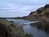
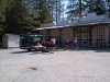
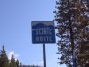
Sag stop at Folsom Lake - very pretty. But the hills started soon afterwards, all the way into Auburn. (We've entered the Sierra Nevada foothills.) Just the same, we got into town about noon. Ran into the group having lunch at a gourmet pot pie restaurant/cafe that just opened today. We had brought sandwiches from the local deli, but they didn't seem to mind. Bruce says not to expect sandwiches like this for many days to come. Field trip to the local bike store in the afternoon. I was sort of looking for a safety vest, but mostly just wanted to get out of the hotel. They didn't have what I wanted, but I picked up a postcard for the World's Toughest Century. They have options from 36 miles with 2500 feet of climbing, to 140 miles with 14500 feet of climbing. I got a peek at the cue sheet for tomorrow - 60-mile climb to Donner Pass, then a bit of a downhill into Truckee. John has got Andy watching CNN. I even caught him watching Fox News this afternoon. I'm going to have to keep a closer eye on his TV watching habits. |

|
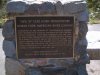
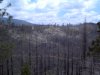
Day 4 - June 11 - Auburn, CA to Truckee, CA - 76 milesThis was the big climbing day, to get up and over Donner Pass. The first 62 miles were almost non-stop climbing, with 8200 feet total elevation change. We started cursing every downhill, because it was elevation that we were going to have to gain back. Magra Road was the worst - the switchbacks were fine, but it straightened out, and went straight up the hill.
Bruce also advised us to get off at mile 40 (about halfway along I-80), and get some lunch at Burger King. We did, and I was glad for the food, but it sat poorly on my stomach for the rest of the ride. Got off I-80 to go over Donner Pass itself. I was disappointed not to find any kind of sign or plaque. I would have like to get a picture there. I'm not even sure Donner Pass is a single geographical point. At any rate, it was pretty clear when we got to the end of Donner Pass. There was a railroad-style barrier they could lower to close the road in winter. Just past that was a scenic overlook, and the descent started.
As soon as we got in, Andy had to look up the highest point in Britain. Ben Nevis, in Scotland, is about 4200 feet. Today we climbed about two Ben Nevises. "I've been higher than any Englishman has any right to be." Dinner was a "pizza party"; it turns out that Pizza Hut has a concession in the hotel, but they do have a beer and wine license, with local beer on tap. Mmm, beer. |

|
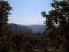
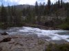
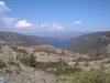
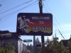
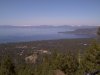
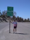
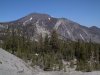
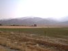
Day 5 - June 12 - Truckee, CA to Sparks, NV - 50 milesInstead of taking the short, dreary route to Sparks, via I-80, we went out of our way to do some more climbing. The day started with a long climb to Brockway Summit (elev 7200 ft), and a screaming descent all the way into Kings Beach CA, on the north shore of Lake Tahoe. Andy left a good 10 minutes ahead of me, but I caught up to him at the bottom. There's really not much to the town - a lot of motels, and one good bakery. A lot of our group stopped there, but it was too soon after breakfast for me. I just got some pictures, and went on. A little up and down to the Nevada border at Brockway, then we started climbing some more. From Incline Village to Mount Rose pass is 8.5 miles, but it took 1:50. Neil and Emily put a mini-sag stop about halfway up, at a particularly scenic switchback, because there wasn't anyone ahead of us, so there wasn't any reason for them to sit in an empty parking lot.
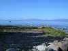
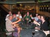
All told, the trip to the bottom took 28 minutes, and lost over 5000 feet of elevation. I wasn't there for more than a minute when Andy and Pat came whistling up behind me. I won't speculate on Pat's age, but her husband Bert is retired. Anyway, she's a strong rider. Sadly, Nevada is not nearly as bike-friendly as California. For the first (and probably last) time, Andy and I beat our roommate John to the hotel. Of course, John had crawled back into bed after breakfast, but he was at the pass before we left it, so he had some chance of passing us. I skipped the "100% attendance please" seminar on how to clean and lube your bike, and did my laundry. This was the first place we've stayed since San Francisco that didn't have guest laundry machines, so I had the hotel van take me up to a local shopping plaza. It was only half a load, but it was all my jerseys and shorts, and most of my socks, so it wasn't something I could put off another day. Dinner was at the Nugget Hotel/Casino in Sparks. They put on a really nice buffet - a bit light on the vegetables, but a nice salad bar, lots of entree choices, and a killer dessert buffet. Afterwards, I had drinks with Andy, John, Dan, Marnie, Daco, and Tom down in the sports bar. It was well deserved, and we all know we're not going to see a bar like this for many days to come. I didn't manage to connect with my cousin Mark, who lives in Reno, and who I haven't seen in something like 25 years. I'd been playing phone tag for a couple days, but I forgot to bring my phone to dinner, so I missed the call when he was actually somewhere in the same building. |


|
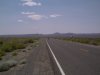
Day 6 - June 13 - Sparks, NV to Lovelock, NV - 92 miles
Getting out of Sparks was not fun. It's much less bike-friendly than anywhere in California, so we had to dodge traffic getting to the freeway, and there was a lot of traffic on the freeway for the first 10 miles or so. This section of I-80 is also concrete, and has what I will charitably assume are old-style rumble strips, cast in place. The shoulder is about 8 feet wide, but the rumble strips are about 4 feet wide, on the right hand side, forcing you to ride closer to the traffic than you might otherwise. I also have a hard time imagining how many accidents they might prevent, since by the time a car hits the rumble strip, it's practically off the road anyway. After about 10 miles, we got to newly-paved asphalt, with modern ground-in rumble strips just inside the shoulder - i.e. between us and the traffic.
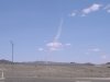
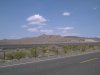
Even though you're on the interstate forever, and the scenery doesn't change a lot, you have to stay alert for truck-tire schrapnel. A lot of people got flats from stray wires from the steel-belted radial tires. I didn't, but I was pretty anal about running my glove over the tires every time we passed through a bad patch. There was a nice long section of salt marsh outside of Sparks - lots of grasses and occasional pools, with all sorts of birds nesting. It floods in the spring, just a few inches deep, but over a very broad area. I've seen it flying into California, and it always looked neat. That eventually gave way to barren clay and sand, and we entered the Fourty Mile Desert, the most dreaded section of the Emigrant Trail. Rode today with Dan (except when he dropped us - yes, I was dropped by a one-legged man with a sprained ankle), Andy, Carol, and (later) Marnie. Marnie's knee was still bothering her from the climb, so she didn't mind hanging back with us old folks, even though she's a racer, and she's riding a carbon-fiber Trek Postal Team bike. |


|
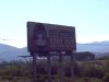
Day 7 - June 14 - Lovelock, NV to Winnemucca, NV - 74 milesOnly about half the day was actually on I-80. There were two new hazards today: Mormon crickets and concrete rumble strips. Mormon crickets are these honking big (about 2" long) reddish-brown insects that like nothing better than to sit on the shoulder of the highway. They can't fly, but they can hop up to a mile a day, and they eat everything, including road-kill (including other Mormon crickets). Nevada laid a lot of concrete highway several decades ago, before rumble strips were really well-understood. Yesterday, we had rumble strips on the right half of the shoulder. Today, we got them all the way across the shoulder, so we couldn't go around them without going into the travel lane. They come in sections about 4 or 6 feet across, about 100 to the mile, for 11½ miles into Winnemucca. After cashing in our free drink coupons at the casino, a bunch of us decided to see the town, and ended up in a good-ol'-boy bar called the Dubble SS Saloon, where we out-numbered the locals. Shot some pool, drank some more beer. After all, it was Saturday night in Winnemucca. |

|
 We had fog and drizzle and climbing and flats and sun and heat and
cross-winds and everything today.
We had fog and drizzle and climbing and flats and sun and heat and
cross-winds and everything today.
 McGary Rd in Fairfield was closed to traffic after the earthquake and is
emphatically fenced off. Fenced all the way across, with a "No
Trespassing" sign at the far end. But that's where we were going, so
we slipped around the fence at one end, and under the fence at the
other end.
McGary Rd in Fairfield was closed to traffic after the earthquake and is
emphatically fenced off. Fenced all the way across, with a "No
Trespassing" sign at the far end. But that's where we were going, so
we slipped around the fence at one end, and under the fence at the
other end.
 Cue sheet for today started out: Get back on the bike path for 33
miles. The Bike paths here are wide, flat, well-paved, clean, with
water fountains and bathrooms periodically.
Cue sheet for today started out: Get back on the bike path for 33
miles. The Bike paths here are wide, flat, well-paved, clean, with
water fountains and bathrooms periodically.
 Andy and I took an inadvertant detour towards Folsom. Tbhe directions
weren't all that great, and we missed the turn onto the bridge. We
figured it out after we crossed Rt 50, and started heading into town.
Andy and I took an inadvertant detour towards Folsom. Tbhe directions
weren't all that great, and we missed the turn onto the bridge. We
figured it out after we crossed Rt 50, and started heading into town.
 We were parallel to I-80 for most of the day. For a 16 mile section,
we were on I-80. In the map rap last night, Bruce said not to
get too worked up about it, that it's like the bike trail we were on
in Sacramento (except for the 70 mph traffic off to the side). In
fact, the first section had a wide, flat, clean shoulder. The second
half wasn't in as good condition, and had considerable sand and
truck-tire debris. The climbing was long but not steep, so really, it
wasn't bad.
We were parallel to I-80 for most of the day. For a 16 mile section,
we were on I-80. In the map rap last night, Bruce said not to
get too worked up about it, that it's like the bike trail we were on
in Sacramento (except for the 70 mph traffic off to the side). In
fact, the first section had a wide, flat, clean shoulder. The second
half wasn't in as good condition, and had considerable sand and
truck-tire debris. The climbing was long but not steep, so really, it
wasn't bad.
 We lost 1200 feet of elevation in something like 3
miles. I was all the way out in the traffic lane, because I was going
as fast as the cars (even gaining on them), even while braking pretty
heavily. I almost hit a chipmunk at 30 mph, which would have been bad
for both of us. My max for the day was 41 mph, but I don't think it
was there; I think it was on one of the shorter, straighter downhills,
where I wanted as much momentum as possible going into the next hill.
We lost 1200 feet of elevation in something like 3
miles. I was all the way out in the traffic lane, because I was going
as fast as the cars (even gaining on them), even while braking pretty
heavily. I almost hit a chipmunk at 30 mph, which would have been bad
for both of us. My max for the day was 41 mph, but I don't think it
was there; I think it was on one of the shorter, straighter downhills,
where I wanted as much momentum as possible going into the next hill.
 Bud had a sidewall blowout 13 miles out, about 10 minutes after the
sag van passed him. The next time the van came around, he was more
than 10 miles behind the last rider, so it turned around and missed
him again. He ended up sitting there for an hour and a half before
the van finally got to him. (He wasn't stuck there alone - Cindy was
sitting with him.) At the route rap, Bruce talked about how spotty
the cellphone coverage can be in Nevada, and how important it is to
carry your own supplies. What he didn't mention, but everyone knew,
was that cellphone coverage was just fine where Bud was, but they
didn't have the phone turned on in the van.
Bud had a sidewall blowout 13 miles out, about 10 minutes after the
sag van passed him. The next time the van came around, he was more
than 10 miles behind the last rider, so it turned around and missed
him again. He ended up sitting there for an hour and a half before
the van finally got to him. (He wasn't stuck there alone - Cindy was
sitting with him.) At the route rap, Bruce talked about how spotty
the cellphone coverage can be in Nevada, and how important it is to
carry your own supplies. What he didn't mention, but everyone knew,
was that cellphone coverage was just fine where Bud was, but they
didn't have the phone turned on in the van.